GIS 5935 Lab 2 - Data Quality Standards
Lab 2 of GIS 5935 involved determining the positional accuracy of two existing road networks compared to the true locations of the roads. The two existing road networks used in the lab were the City of Albuquerque and the StreetMap USA streets feature classes. The accuracy was determined by following the procedures provided by the National Standard for Spatial Data Accuracy (NSSDA).
The first thing was to locate a minimum of 20 test points for each of the two existing road networks. These points needed to be at intersections that formed right angles. The test points also needed to be spread out in the study area with a minimum of 20% of the points being in each of the four quadrants. The points also needed to be spread apart by a minimum of 1/10th of the diagonal of the study area.
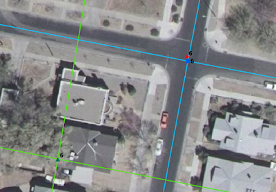
The map below shows a sample intersection. The blue line represents the City of Albuquerque Road network, and the green lines represents the StreetMap USA road network. The red dot is the true location of the center of the intersection.
Below are maps of the 24 points in
the study area with 6 points in each quadrant which meets the minimum of 20% in
each quadrant. The diagonal distance of the study area is 49,170 feet and each
point is greater than 4917 feet from each other, which is greater than 10% of
the diameter. All points are at right-angle intersections.
Test points for City of Albuquerque Streets.

Test points for StreetMap USA Streets.

Next step was to locate the true
locations of the intersections for each of the test points using a
high-resolution orthophoto. This involved zooming into the location of each intersection
and digitizing the edge of pavement across the intersection to form a box. The true
location of the intersection would then be digitized at the center of the box.

The XY coordinates of each point was then added to the feature class attribute tables and exported to excel files. The coordinates were then added to the NSSDA Positional Accuracy Worksheet to calculate the results.
The results for the horizontal accuracy for each of the two road networks:
Positional Accuracy: Tested 14.23 feet horizontal accuracy at 95% confidence level.
Positional Accuracy: Tested 362.46 feet horizontal accuracy at 95% confidence level.

Comments
Post a Comment