Posts

Showing posts from March, 2023

Module 2 - Typography

Image
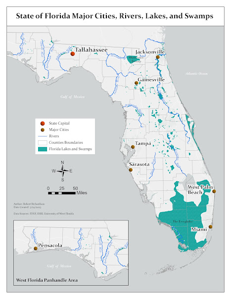
Module 2 assignment for the Cartography class was to create a map of Florida that illustrated major features of the state. The map needed to include features and labels for major cities, rivers, lakes, and swamps. The objective of the assignment was to create a map that had all the required features symbolized and labelled in a way that uses proper placement and observes typographic principles. The map was created using ESRI ArcGIS Pro and a geodatabase that contained feature classes for the Florida capital, counties, lakes and swamps, major cities, and rivers. The map creation involved adding the needed features to the map, appropriately symbolizing each feature, and labelling the features to be legible. There were some customizations done to improve the overall presentation of the map.  The first customization on the map was creating an inset map to show the Western Panhandle of Florida. The reason for doing this was due to the shape of the state, which made it difficult to fit the

Module 1: Map Critique

Image
Module 1 of Computer Cartography we were tasked with evaluating and critiquing a well-designed map and a poorly-designed map. We evaluate each using established cartographic design principles that look to determine the substantive and affective objectives of each map, the intended audience, cartographic design, map elements and page layout. I selected the South Carolina Wildlife Management Area Game Zones as the well-designed map, and the U.S.A. Sitcom Map and the poorly-designed map. Well-Designed Map The map for the South Carolina Wildlife Management Area Game Zones is a perfect example of a well-designed map since it meets the requirements of the Tufte’s 6 commandments. The map’s intended purpose of showing the game zones is effective with efficient use of map space and use of symbology that stands out and is easily understood. The map is labeled in a way that is easy to read with no additional explanation needed. All the elements on the map are well placed and size with no unnecess

GIS Training Map

Image
Map created in the GIS User Certification Training  

About Me

  My name is Robert Richardson, and I am working on a Masters in GIS Administration. I have been utilizing GIS for over 15+ years but have only taken a couple of formal classes in GIS. I received bachelor’s in computer information systems from the University of North Florida (UNF) where I am also currently working as the Assistant Director of Research Technology Services. My role at UNF is helping faculty and students with their research needs and one of my main areas of interest is GIS. I joined the Masters in GIS Administration program because getting a degree in GIS has always been something I have wanted to do but I kept putting it off.  View my Story Map for more information.