Module 2 - Typography
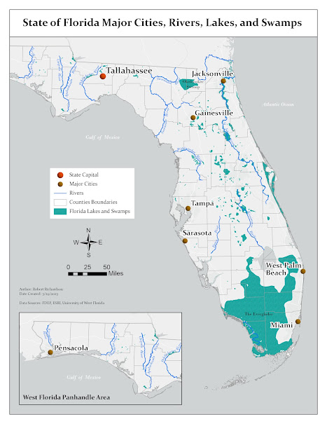
Module 2 assignment for the Cartography class was to create a map of Florida that illustrated major features of the state. The map needed to include features and labels for major cities, rivers, lakes, and swamps. The objective of the assignment was to create a map that had all the required features symbolized and labelled in a way that uses proper placement and observes typographic principles.
The map was created using ESRI ArcGIS Pro and a geodatabase that contained feature classes for the Florida capital, counties, lakes and swamps, major cities, and rivers. The map creation involved adding the needed features to the map, appropriately symbolizing each feature, and labelling the features to be legible. There were some customizations done to improve the overall presentation of the map.
The first customization on the map was creating an inset map to show the Western Panhandle of Florida. The reason for doing this was due to the shape of the state, which made it difficult to fit the entire state on a map that was designed to fit a letter-sized sheet of paper. This was done by using two map frames on the layout with both frames referencing the same map. The main frame was positioned to cover almost the entire page layout minus the margin. The map extent for the main frame was most of Florida except for the western panhandle. The inset frame was positioned in a white space area at the lower left of the page layout on top of the main frame. Both frames were set to scale at 1:3,168,000 or “one inch equals 50 miles.”
The second customization on the
map was to symbolize the capital city and the major cities using a 3D symbol
and different colors. The City of Tallahassee has a larger symbol and label size
to illustrate that it is more significant being the capital of Florida.
The final
customization was labelling the rivers in a way that was legible and followed
the shape of the rivers. The module 2 lab instructions went through how to add
labels to the river and then create annotation from those labels, but the
results were not satisfactory for a clean looking map. My process for the river
annotation was to first create a generalized river feature class that was smoother
and less detailed than the original river feature class. The generalized river
feature class was used to create the river annotation. Editing tools were then
used to move and reshape the annotations to follow the river.


Comments
Post a Comment