Module 2.3: Scale Effect and Spatial Data Aggregation
This module involves the concepts of scale effect on vector data, resolution effect on raster data, and gerrymandering of congressional district boundaries.
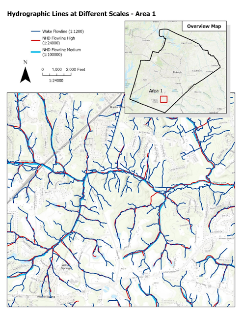
Scale effect refers to the relationship between how real world of features are represented and the change in accuracy as the scale is changed. The shape of hydrographic features can be represented differently based on the scale and the density of the points collected. The larger the scale, the more detailed and realistic the feature becomes, which increases the length and accuracy of the feature. The numeric results in the table above illustrate that as you go from a larger to smaller scale, the measurements decrease.
The map below shows three different
hydrographic datasets that were created at different scales. The smaller the
scale the more detailed and closer to realistic representation of the actual hydraulic
feature.
Resolution effect on raster data
refers to the cell size of the grid and how well it represents the true earth
features. Higher resolution provides more detail and better represents the
features on the ground and lower resolution is more generalized the surface of
the earth. Below are three Digital Elevation Models (DEM) at 1-, 30-, and
90-meter resolution. The 1-meter resolution provides more detail and better represents
the surface of the ground.


Gerrymandering is a term used to describe boundaries
that are drawn to give an advantage to one political party or group of individuals.
One way to measure Gerrymandering is by determining compactness which is a
ratio of the circumference of a district and its total area. The Polsby-Popper
score uses the formula (4π * AREA) / (PERIMETER ** 2) which
produces a score range 0 to 1. Scores closer to one are more compact and lower
scores are less compact. The below map shows the North Carolina Congressional District
12 which was the worst compactness offender of all the other districts in the
US with a score of 0.03.


Comments
Post a Comment