Module 6 – Suitability Analysis
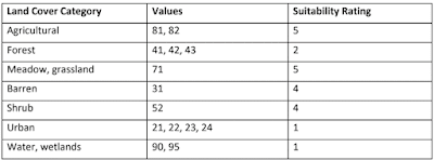
One of the scenarios in Module 6 involved performing a suitability analysis for a developer who was looking to purchase some land to build a development. This analysis rated five different criteria to determine the best suitability for the land. The five criteria were land cover, soils, slope, distance from streams, and distance from roads. Below are the 5 criteria and the rating given to different values. A rating of 5 is the most suitable while a 1 is the least suitable.
A raster layer for each of the
criteria was created based on the suitability rating. The ArcGIS Weighted
Overlay tool was used to create a single raster that combined all 5 criteria
and multiplied a percentage of influence on each criteria. The map below shows
two different approaches to the weighted analysis. The top map shows the
approach of equal weight where each category has an equal influence and is given
a percentage rating of 20%. The bottom map shows the results of an alternative weight
where land cover and soils each have 20% influence, distance from streams and
roads each have 10% influence, and Slope has 40% influence on suitability.


Comments
Post a Comment