Module 3 - Ward 7
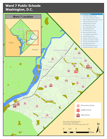
Module 3 assignment for the Cartography class was to create a map showing the location of Public Schools in Ward 7, Washington D.C. The assignment focused on the utilization of Gestalt’s Principles of Visual Hierarchy, Figure-ground distinction, Contrast, and balance. The map needed to contain a frame that focused on the Ward 7 area and an inset frame that showed the location of Ward 7 within the Washington D.C. area.
ArcGIS Pro was used to create the map using provided data from District of Columbia Open data. A Geodatabase was provided that included a point feature class of all the Public Schools in Washington D.C., the Ward 7 and Washington D.C. boundaries, parks and surface water, and different levels of transportation layers.
Visual hierarchy was implemented on the map by using symbology that brings the school locations to the forefront of the map. The reddish hue of the school’s symbols makes them stand out as the most important feature on the map. The reader is then directed to the Ward 7 study area and then to the other elements of the map.
The figure-ground relationship on both the main map and the location map was established by using a lighter color for the foreground area and a darker color for the background. Ward 7 area uses a lighter green color, and the Washington DC area has a darker version of the same green hue. The Ward 7 area is perceived to be in the foreground and the Washing DC area in the background.
The map was balanced on the page
by placing Ward 7 at the visual center of the map at a reasonable scale to
allow it to be as large as possible. The shape of Ward 7 allows for several open
spaces to fit the location inset map and the other map elements to provide a balanced
layout.


Comments
Post a Comment